Tuesday, April 12, 2011

Sat Antennas - New UHF Feedline and Pre-Amp


It's amazing how much UHF power can be consumed in sub-optimal connectors! A week ago I measured the 70cm power output at the Az/El antenna system, and found only 2 watts was reaching the antenna! The FT-817ND was putting out almost exactly 5 watts, so this means 60% of the power was being lost in the feedline, connectors, and coax.

I did some quick measurements with the transmitter and a dummy load, and determined that most of the loss was actually coming from the SO-239 to BNC adapters I was using to connect my PL-259 terminated cable with my BNC-connector 70cm preamplifier. The actual loss in the RG8/U cable (Tandy, almost 20 years old) was fairly minimimal in comparison.

Based on this, I decided to get rid of the adapters entirely and replace the whole UHF feedline system with 40 feet of LMR-400, terminated in N-connectors at the preamp, and to use a pre-amp with stock N-connectors. This reduces the total number of connectors to a minimum: a PL-259 at the radio, N-connectors in and out of the preamp, and another PL-259 at the antenna.

I haven't measured the direct losses yet, but calculations show negligable losses from the connectors, less than 0.5 dB from the preamp itself, and around 1.1 dB for the LMR feedline. That should result in something more like 4 watts reaching the antenna, instead of the 2 watts I had last week. Woohoo!

Receive audio seems much better, and downlinks from AO-07 and VO-52 (both 70cm uplinks) seem strong as well.

Thursday, January 27, 2011

January VHF Contest - Mt Diablo


The ARRL January VHF Contest was the weekend of Jan 22-23 this year. Last year I operated from Mt Vaca (CM88), but this year I decided to operate QRP in the "Single Operator Portable" category from the summit of Mt Diablo (CM97). Mount Diablo is a 3950' peak situated roughly in the middle of California's central valley, with line-of-sight views for hundreds of miles in many directions. Rather than hiking, I took the easy way and drove to the summit, and used the truck's Yaesu FT-857D radio with power output turned down to contest QRP levels (10 W).


For antennas, I used the Elk dual-band log periodic array for VHF and UHF, and I used the truck's screwdriver antenna for 6 meters. Things worked out well -- in 3 hours I was able to make 78 QSO's over 9 grid squares in three bands. Weather conditions were perfect -- temperature around 60F, with sunny skies and calm winds.

Sunday, January 9, 2011

Home Satellite Station!


This weekend I replaced the 4-element Arrow VHF beam antenna with a 7-element M-Squared 2M7 VHF beam. The main reason for this was because the Arrow wasn't weatherproof, and I had to get it out of the rain before it corroded. A secondary reason was that the M-Squared antenna has quite a bit more gain than the Arrow -- I've found that this really helps pull the sometimes weak VHF-downlink signals out of the VO-52 and AO-07 sats. Here are some photos of the new installation: The twin Yaesu FT-817ND tranceivers and the Amsat LVB Tracker. The tracker is on left with the green display. The FT-817ND on the bottom with the orange display is used for VHF and is connected to the VHF yagi, while the FT-817ND on the top with the blue display is used for UHF and is connected to the UHF yagi:


This is the Yaesu G-5500 rotator controller. It's directly controlled by the LVB Tracker, and it connects directly wtih the rotators:


The cable feedthrough allows the two rotator cables and two antenna feedlines directly through the office wall. I wanted to keep the cable run as short as possible, so this hole is right beneath the radios. It isn't pretty but it's functional:


The antenna feedlines go to the preamplifier box mounted on the antenna tripod mast:


The preamp box houses the Advanced Receiver Research (ARR) pre-amps. One for 70cm and one for 2m. Both are switchable from inside the office:


Here's a view looking down (up?!) the two antennas. The M2 2M7 VHF antenna is on the left, and the 15-element Diamond yagi is on the right:


And here's the whole assembly:


And in this photo, the proximity of nearby houses is visible. Houses limit the visibility of the antenna to around 15 degrees to the south and 23 degrees to the north.


Finally, here's a short video of the antenna rotation in action:


Here's a list of the station components:

Support Mast:
10' steel pipe 1 1/2" diameter
Older style Radio Shack TV Antenna Tripod
Redwood 2x4 and concrete pier base

Rotator:
Yaesu G5500

PreampS:
Advanced Receiver Research SP432VDG - N connectors
Advanced Receiver Research SP144VDG - BNC connectors (not in use)

Antennas:
UHF Ant: Diamond A430S15 15-element yagi, mounted horizontally.
VHF Ant: M2 2M7 7-element yagi, mounted vertically.

Preamp Box:
Weatherproof camera box mounted to TV-mast support x 2.

Coaxial Cable:
VHF Feed (shack to box): 30' Tandy RG-8/U, PL-259x2
UHF Feed (shack to box): 30' Times Microwave LMR-400, PL259 + N connector
VHF Feed (box to ant): 8' Tandy RG-8/U, PL-259x2
UHF Feed (box to ant): 8' Times Microwave LMR-400, PL259 + N connector

Rotator Cable:
Rotator: Wireman 302 (2x40)':2-16, 6-18 Premium rotor cable, PE jacket
Rotator: Wireman 352 (2): 8 pole molded connector, male and female set.
(Molded connectors attached to controller end of cable)
(PowerPole connectors attached to 16-gauge lines to provide power to preamp box)

Rado Interface:
Yaesu CT-62 serial:CAT x 2
Serial-USB Adapters x 2 (FTDI chipset)

Rotator Interface:
LVB Tracker from AMSAT

Software:
SatPC32
Computer OS: Windows 7 - 64-bit

Radios:
2 x Yaesu FT-817ND

Monday, January 3, 2011

Satellite Antennas, Continued!


I spent part of the New Year's weekend moving the satellite array from the testing location (next to my garage, between two houses) to it's more-or-less final location in the backard (now between four houses!).


The new location gives a little more view of the sky -- it's pretty clear to the east and west (views down to about 10 degrees), and is limited by my own house to the south (about 18 degrees) and a towering 2-story neighbor's house to the north (about 23 degrees).

The antennas are the same as I used during testing -- a 4-element Arrow for the VHF side, and a 15-element Diamond for the UHF side. Both antennas feed to ARR pre-amps mounted on the mast; I keep the UHF pre-amp powered on all the time, but only intermittently use the VHF pre-amp since there is so much VHF noise in the local area.

The platform that the antenna sits on is built from 2x4 redwood and concrete block pylons. Pictures below!


I also modified the Yaesu G-5500 rotator controller to improve its accuracy. I had found that the controller sometimes had a drift or error of around 10 degrees, and searches on the internet indicated a cause of this problem could be the 7806 voltage regulator inside becoming unstable and oscillating. I checked out my regulator with an oscilloscope, and found that it was indeed oscillating by up to 100 mV at around 5 MHz. To solve this, I added a 0.1 uF tantalum capacitor directly to the bypass capacitor (0.01 uF) that's installed on the regulator output. This removed the oscillation, and now the rotator controller's accuracy is dead-on.

Saturday, January 1, 2011

California Lost Coast (CM79/CM89/CN70/CN80) Expedition

Dates: August 6-9 2011
QRV: Aug 7-8 2011
Modes: Satellite (+?)


Plans
Plans are coming together for a satellite mini grid-expedition in early August this year. The location will be the rare grid square CM79, along with the adjoining CM89/CN70/CN80 grid squares. I plan to camp out near Shelter Cove on the remote northern California Lost Coast area, arriving on Saturday August 6th. As weather conditions permit, I hope to operate as much as possible on the 7th and the 8th, and will return on the 9th. I'll work both linear and FM satellites: AO-51, SO-50, SO-67 (if on), ARISSAT-1, AO-27, VO-52, FO-29, and AO-07.

Location
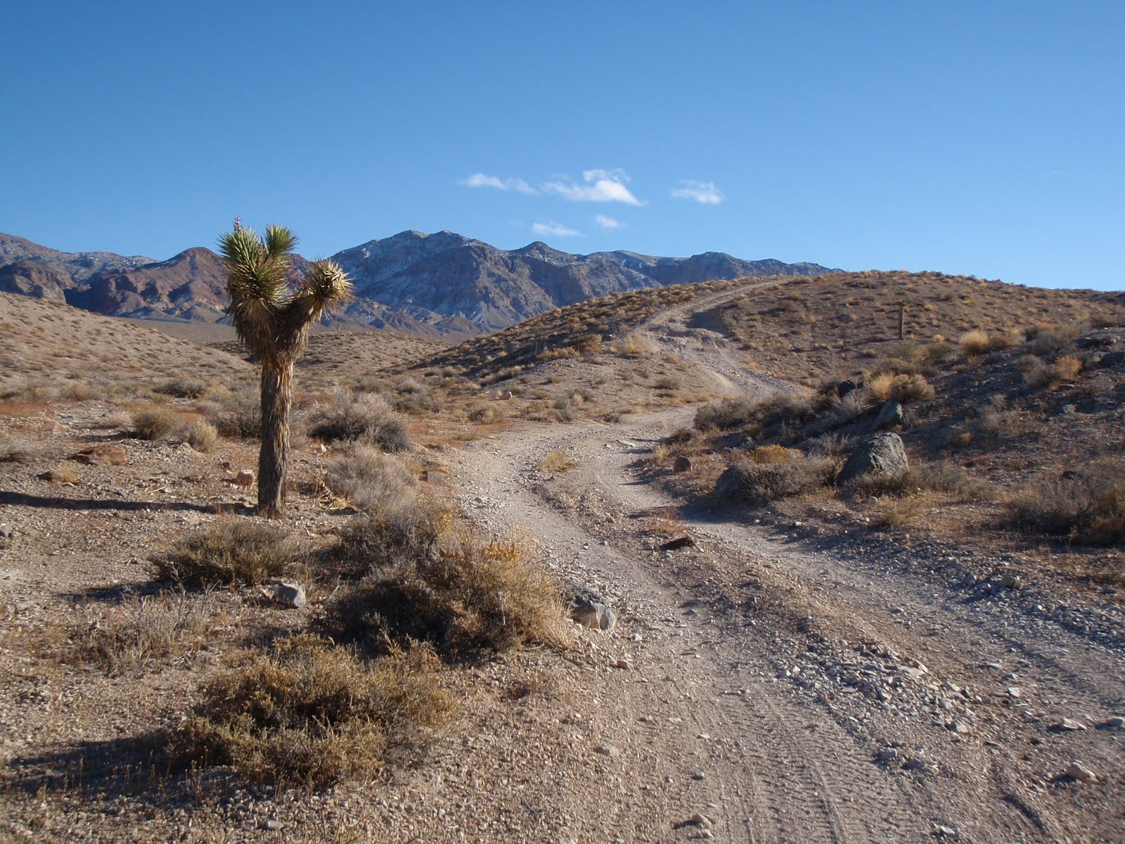
Grid square CM79 is almost all ocean, with a small portion of the northeast grid corner extending up into the rugged California Coast Range. The actual grid boundary is reportedly 70 feet down a steep hillside from a ridge on Chemise Mountain. Looking at photos on the Confluence.org site, it seems the exact grid intersection is in a grove of oak and manzanita, and is already marked with a yellow box used by GeoCachers (http://confluence.org/confluence.php?visitid=2928). There's a hiking / pack trail that extends from a nearby campground, up about 1.5 miles to the ridge. If all goes well, I'll hike the trail with the portable satellite gear, and set up the station at the grid intersection.


Equipment
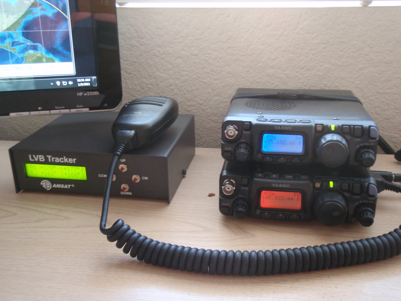
The equipment I'll use will be the same setup that I used on the previous Death Valley and Eagle Lake expeditions. This setup consists of twin Yaesu FT-817ND radios, an Elk antenna, a netbook computer for tuning and tracking, and PowerFilm solar panels.

Technicalities
The ARRL VUCC requirements indicate that "... the total area occupied by the station's physical setup, including operating position(s), power source(s), and antenna(s), must occupy some portion of each of the two/four grid squares simultaneously.". In order to achieve this, a combination of a centralized station (directly over the grid intersection) and a decentralized station (still directly over the grid intersection but with antenna located on the ridge) will be used depending on the particular satellite pass. This has been discussed with ARRL HQ and the plan has been confirmed as acceptable for VUCC credit:

Overhead and Westerly satellite passes:
Full station set up directly over grid square intersection. Specifically, I'll use the standard setup that I have used before, consisting of two Yaesu FT-817ND radios hanging from a photographic tripod, with the 6.4Ah LiFeP04 battery right next to the tripod. The antenna is an Elk antenna on top of the tripod. The area of the grid intersection will be marked with a ground tarp, and will be determined with better than 20' accuracy with WAAS-GPS. Photo and video will be used to document the station, GPS receiver, and surroundings.

Easterly satellite passes:
Since the view to the east is blocked by a ridge, 70' uphill, for easterly passes I will use the exact same station as above, except that the Elk antenna will be relocated to a second photographic tripod perched on the ridge. The Elk will be connected via 100 feet of LMR-400 coax, and I will use a preamp at the antenna to help overcome the signal loss on the 70cm downlink. As above, all station operation will be from directly over the grid intersection, including tuning, transceivers, and power source. The Elk can be re-aimed once or twice through the satellite pass to more or less keep up with the sat as it moves.

The disadvantage of the remote antenna setup is that it's using the single 100' LMR-400 coaxial cable for both transmit and receive. As such, the antenna-mounted preamplifier will switch off during transmit, so I'll effectively be operating half-duplex while on the V/U birds during lower easterly passes. Of course, the big advantage of the remote antenna + preamp is that it allows operation on easterly satellite passes without compromising the integrity of the station physically located on the grid square boundaries. Thanks to ARRL HQ Awards Branch for their suggestions and review of this plan.

Non-Satellite Modes
The primary goal of this expedition is to provide satellite contacts for people wishing to log the rare grid squares in this area. That being said, I will have the 2m/70cm antenna with me, so I may try some terrestrial SSB contacts. The weekend of the 6th/7th is the ARRL UHF contest, so if I hear anyone on 432.100 SSB, I'll try to contact them (remember I'm only running 5 watts QRP!). I also might bring the 6m HO Loop antenna for 6-meter sideband, but it's unlikely there will be any Es openings on 6 this late in the season. Since satellite operation is primary, operating on secondary modes will mainly depend on power budget (sunny = lots of power -- foggy or cloudy = will have to be careful).

Real-time GPS Tracking
I'll have my SPOT statellite tracker with me, and it will give the actual location of my position in real-time. Checking the SPOT page below will be the best indication of whether I'm at the operating position or not.
http://share.findmespot.com/shared/faces/viewspots.jsp?glId=07htI1NLFXRPkuxjfKceuGRTSqpQncKQ2


Pass Predictions
The following table shows the passes that I hope to be able to work. I'll work the linear satellites in the mid-to-upper end of the passband in SSB. Oscar 7 mode A is unlikely, but I may give it a try with a wire antenna for the downlink. I'll try to get on ARISSat-1 if it's available, and will cross my fingers that AO-51 is up and running as well. Due to the nature of the CM79 area (remote!!!) I won't be operating after dark, so the following table shows the daylight passes on local Sunday and Monday:


Checklist
The following is a rough checklist of the main items that I'll be bringing to the operating position. The system will be the same full-duplex portable satellite station that I have used in prior expeditions. In case the netbook computer that provides satellite tracking and doppler control goes down, I'll bring a backup frequency chart and pass prediction tables.

==== Radio =========
[] Yaesu FT-817ND x 2
[] Sat cable harness incl. diplexer
[] 6' RG-8x cable with PL-259's
[] 100' LMR-400 cable with PL-259's
[] Advanced Receiver SP432VDG low-noise preamp
[] Tripod x 2
[] Elk 2m/440 antenna
[] Netbook with SatPC32 and updated Keps
[] Boom mic headset

==== Power =========
[] 12.8V 6.4-Ah LiFePO4 battery
[] Solar Panels (60 watts total)
[] Charge Controller
[] Powerpole 4-way adapter
[] 16-ga Red/Black cable (100' + 50')

==== Misc ==========
[] Compass
[] GPS
[] SPOT tracker
[] Digital recorder
[] Log book
[] Sat frequency chart
[] Pass prediction tables
[] Medium backpack

Monday, December 20, 2010

New Satellite Antennas!


Now that the weather has started to turn wet here in Northern California, operating with the portable satellite rig in my backyard is getting more difficult. Not to mention, the Twin FT-817's don't like being in the rain any more than I do!


I've just finished putting together my outdoor satellite antenna installation. Since the radios are indoors (to keep them and me dry), and the antennas are outdoors, they need to be steered via an azimuth / elevation control rotator. Here is a detailed description of the installation:


Antennas:
UHF Ant: Diamond 15-Element UHF Yagi (model A430S15, 85", 14.8dBi)
VHF Ant: Arrow II 2m 4-Element VHF Yagi (model 146-4 with MB/II bracket)(48", 8.7dBi)

Rotor:
Yaesu G5500 Az/El Rotator (450 deg Az / 180 deg El)

Mast:
5-foot steel mast on 3' tripod base.

Cables from Antenna to Premap box:
VHF: 6-foot RG-58/C patch cable with BNC connections from Palomar
UHF: 10-foot RG-8/U with silver/teflon PL-259 connections

Preamp Box:
B&W Systems weatherproof plastic box, #10.

Preamps:
Advanced Receiver Research 70cm GAsFET 25W RF-sensing preamp (SP432VDG)
Advanced Receiver Research 2m GAsFET 25W RF-sensing preamp (SP144VDG)

Cables from Preamp Box to Shack:
Rotator Control: 2 x Wireman #302 40' 2-16/6-18 rotor cable
(12VDC power carried on the 2x16 spare lines in rotor cable to preamps)
VHF Feedline: 25' RG-8/U with standard nickel PL-259 connections
UHF Feedline: 25' RG-8/U with silver/teflon PL-259 connections


Rotor Controller:
Yaesu G5500 Az/El dual Rotator Controller

Rotor Controller Controller:
LVB Tracker (from AMSAT, on order)


Transceivers:
VHF: Yaesu FT-817ND
UHF: Yaesu FT-817ND

CAT Interface:
2 x Yaesu CT-62 CAT cables (either USB<->CAT or USB<->Serial Convertor<->CAT)


Controlling Software:
SatPC32

Computer:
Samsung Netbook N150S

Saturday, November 27, 2010

Death Valley 4WD Trip Report


This is a trip report from a mini satellite "DX-pedition" to the remote valleys in northern Death Valley National Park. The entire route of the trip was recorded by a Spot Satellite Messenger and is shown in this trip map on Google Maps. The trip combined two of my favorite things -- remote backroads four-wheel driving and ham radio! The area around Death Valley doesn't have too many hams, so the latitude/longitude grid squres are pretty uncommon on the air. My main radio time was spent working the orbiting ham radio satellites. All in all, I had around 60 QSOs from the two rare grids (DM17 and DM16) with 21 separate satellite passes over the three days of operation.


For radio equipment, I brought along the twin FT-817 setup described in my earlier post. The station all packs into a small laptop computer bag, and I can set it up in about 10 minutes. The vehicle was a 2005 Toyota Tacoma 4WD, and worked well in the remote and rough back roads in this part of the country.

Monday (11/22/2010)
Monday we drove from Fairfield, over the Sierra Nevada at Lake Tahoe, and down highway 395 to Big Pine. From Big Pine it was another hour and a half along Death Valley Road and South Eureka Road to the Eureka Sand Dunes. We camped overnight at Eureka Dunes and I was able to make a number of contacts from that location.


Satellite Contacts From Eureka Dunes (DM17dc)
AO-07 (11/23/2010 0215z): Nothing heard, sat was in Mode A.
FO-29 (11/23/2010 0257z): Called CQ for approx 10 min during pass, good downlink return signals but no one else on bird.
VO-52 (11/23/2010 0355z): Worked WA6ARA and N8RO. Noticed doppler shift was way off due to not resetting the observer grid in SatPC32.


Tuesday (11/23/2010)
Tuesday we planned to drive from Eureka Dunes to Upper Warm Springs in the Saline Valley. This route goes through remote Dedeckera Canyon, up over Steele Pass, past the Marble Bath, and down into northeast Saline Valley. Before packing up the site I was able to make a few more contacts from the rare grid DM17:

Satellite Contacts From Eureka Dunes (DM17dc)
VO-52 (11/13/2010 1543z): WC7V, N7RP, N8RO, WA6ARA.
HO-68 (11/23/2010 1553z): Nothing heard, likely sat was in "off" on this pass.
VO-52 (11/23/2010 1718z): W7JPI, called CQ, no other stations on except for a long QSO.
HO-68 (11/23/2010 1740z): WC7V, N7RP, KO4MA, WA4NVM.
AO-27 (11/23/2010 2003z): AJ5C, K8YSE, K4MDA, N8RO, K7TEJ, KB1RVT, AA5CK, N3SCR, WA4NVM.
SO-50 (11/23/2010 2022z): W7JPI, K7MDH, AJ5C, NS7Q.

After packing up the camp, we then drove around the sand dunes, south through Dedeckera Canyon, and then stopped near Steele Pass to see some petroglyphs. From that location, I was able to work a few more sats:


Satellite Contacts from near Marble Bath (DM16ex)
AO-51 (11/23/2010 2303z): KB5MBJ, N8RO, AJ5C, K8YSE, KI6YAA, W7JPI, N5ZNL, KI4OTG, AA5PK, AA5CK.


We continued driving down into Saline Valley, and after sunset finally stopped at Upper Warm Springs. There, I was able to make a few more contacts -- it was really nice to have some satellite "chats" while sitting at the campfire, the sky had so many stars visible.


Satellite Contacts from Upper Warm Springs (DM16du)
FO-29 (11/24/2010 0202z): W7JPI. No one else on bird. Nice ragchew by campfire!
AO-07 (11/24/2010 0315z): W7LRD. Nice chat.
VO-52 (11/24/2010 0412z): WA6ARA. We were only ones on the sat, nice QSO.


Wednesday (11/24/2010)
The wind really picked up around 0000 local time Wednesday morning, so it was a difficult night in the tent! Before leaving, I was able to make a few more contacts:


Satellite Contacts from Upper Warm Springs (DM16du)
AO-07 (11/24/2010 1516z): WC7V, KC7MG, one station in DM14.
VO-52 (11/24/2010 1600z): WA6ARA, N7RP

We then packed up camp and drove over to the west side of Saline Valley. En route (11/24/2010 1749z), I was monitoring 18.150 HF and heard Dieter ZL8X starting up transmissions from a Kermadec Islands DXPeditition. I called him right back and got a nice 5-9 contact! Other than trying to keep up a sked, this was the only HF work on the trip. Early in the afternoon we arrived at a campsite on an access road to an abandoned mine in Keynot Canyon, on the west side of remote Saline Valley.


Satellite contacts from Keynot Canyon on west side of Saline Valley (DM16br)
SO-50 (11/24/2010 2053z): WC7V, K7CWQ, NM6W.
AO-27 (11/24/2010 2113z): AJ5C, WC7V, K7CWQ, KA5GTM, KG7EZ, K8YSE.
AO-51 (11/25/2010 0000z): WA6ARA, KG6ZVC, KG6NUB, K2AK, K7MDH, AC7SU, KC6LTY, WA9JER.
FO-29 (11/25/2010 0106z): N9AMW, WA6ARA. Doppler shift getting difficult again!
VO-52 (11/25/2010 0254z): N9AMW, W2???. Very noisy downlink for some reason.


Thursday (11/25/2010)
Thanksgiving Day we packed up camp, but before doing so I was able to make one more set of contacts:


Satellite Contacts from Keynot Canyon on west side of Saline Valley (DM16br)
VO-52 (11/25/2010 1618z): N7RP, KG0I.

We then drove the 3.5 hours out of Saline Valley and on to Furnace Creek (paved road, yay!). At Furnace Creek we camped one more night, then returned back to Fairfield on Friday.


Lessons Learned
1. Always remember to reset the grid square locator on the software that controls the doppler correction! The first day I was really having to "fight" the computer control of the radios to get the tuning correct, and only after the pass realized that the netbook computer still thought we were in Fairfield!

2. Be sure to manually reset the computer clock from WWV every day. My netbook time drifted 10 seconds in two days, and this was enough to throw off the doppler correction quite a bit.

3. It would have been handy to bring my HT radio along -- the twin FT-817 setup takes about 10 minutes to put together, making it just a bit inconvenient for side-of-the-road stops to work the FM sats. Since the Yaesu FT-530 full duplex dual-band HT and an Elk antenna work so well, if I had that along with me, I might have made some more roadside stops to do quick FM bird contacts.

4. The Spot Messenger worked well -- it recorded almost all track points and also sent out emails letting others at home know we were safe each night. It has the advantage of working where cell phones (and APRS tracking) don't work, especially in this remote part of the country.


Thank you
Thanks to everyone for making contacts, and the help and chat along the way! I really appreciate it. Special thanks as well to Mike WA6ARA for posting details of my trip on the amsat-bb list, it was good to hear other stations I worked who had been following our progress!