This makes it really easy to see who else is on the satellite. Without having to tune the main radio, I can just watch the waterfall display to see what activity there is. It's simple to identify CW stations, stations tuning up, and SSB transmissions.
Here's a radar plot of tonight's pass (AOS at 4/2/2013 02:42z):

And here is the console display of the SDR program HDSDR. Frequency control is in the lower left, the main waterfall is on the top, and the waterfall of decoded audio signals (a close-up of the main waterfall) is on the lower right. The main waterfall covers from around 145.840 to 145.940 MHz. The solid vertical traces are the local "birdies" coming from various sources of RFI in my area. The waterfall flows from bottom to top, so the whole display is constantly "flowing" upwards. Newest signals are at the bottom, and the vertical span of the waterfall covers around thirty seconds.

At the start of the satellite pass, the downlink is very quiet. You can see my CW identification as a vertical streak around 145.905 MHz. It's actually easy to identify, since it does not extend all the way from top to bottom like the birdies do. VO-52 is only about 2 degrees above the horizon in the south at this point.

As the satellite gets up in elevation a few more degrees, you can now see me calling CQ in SSB around 145.905 MHz. There's also a noise burst around 145.925 MHz.

The satellite is up around 10 degrees at this point, and my CQ calls in SSB are clearly visible:

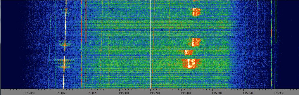
Now that the satellite is around 25 degrees above the horizon, my CQ call in SSB (top) is followed by a CW ID (vertical line), and then another station answers my CQ but is slightly off frequency (about 3kHz below me).

It takes a little while for the other station and I to get lined up, you can see the patchy transmissions. At this point the satellite is at a really high elevation and is moving pretty fast overhead, so doppler is playing a significant role. The sloping vertical line on the left side of the waterfall is VO-52's CW beacon, slanted due to doppler shift.
We're now lined up, and have good strong signals. You can clearly see the noise floor of VO-52's passband, it's the yellow-orange patch in the center of the waterfall from about 145.870 to 145.910 MHz:

As VO-52 continues north and descends towards the horizon, signals start to fade out:

Near the end of the pass, I spun the tuning dial as I was sending a string of dashes in CW, you can see the zig-zag pattern it makes. This is typical of what a "tuner-upper" will look like on an SDR -- their CW will zig-zag through the passband until they (hopefully!) zero in on themselves:

As the satellite continued even lower towards the horizon (about 10 degrees by now), signals were pretty weak. My SSB call is the smudge at around 145.903, and my CW ID's are the orange vertical lines below that.

This was a pretty quiet pass (only myself and one other station), but hopefully it will give you an idea of what a typical linear transponder satellite downlink "looks" like on an SDR display.
No comments:
Post a Comment
Note: Only a member of this blog may post a comment.